Darius Kinsey photos
"The Land of Silent Shadows"
LINK to Part I

Written by Catherine Savage Pulsipher; originally typed & arranged by Mabel Boyd Royal-Steen. typed & transcribed by Larry Spurling; arranged & compiled the Stump Ranch, Dan Royal ©
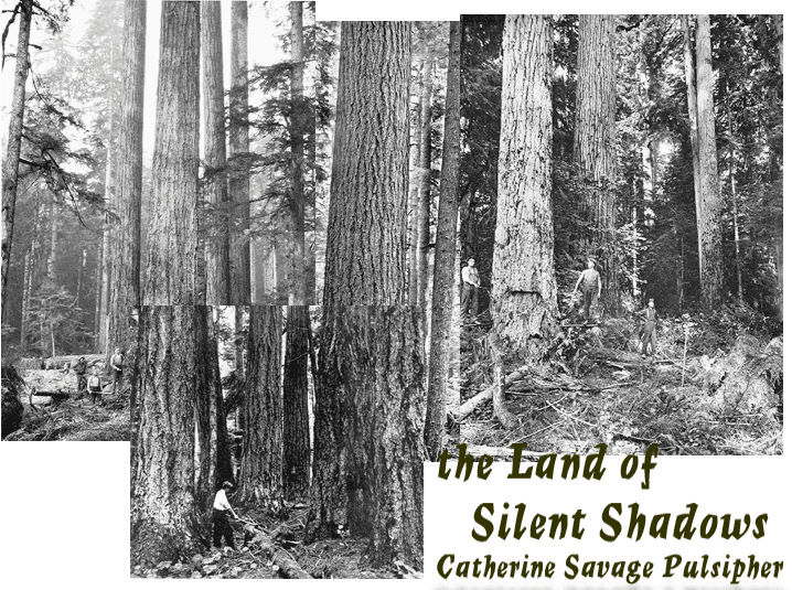
Skagit County's Own Gold Rush

      A little background on "The Land of Silent Shadows." The story is fiction based on real events and people. The only real names I can make out are George & Etta Savage and in-laws Alex & Olive [Mary] Boyd. I honestly can't tell you how real the events are concerning Kate Savages oldest sister Olive Savage and future husband. [If this is them at all?] They must have had talks which Kate based this story on. I've yet to find an Indian account on troubles talked about in this story and elsewhere, though I do have Chief Sampsons book coming; "Indians of Skagit County."
      Reading on this Gold Rush period adds a new perspective and reason as to what brought Alex and Mary Boyd out from Nebraska. We've always stated in the family histories that Etta was always writting letters to her sister Mary Boyd encouraging her family to come out to Gods Country, but this minor Gold Rush must have been inviting to Alex Boyd who did file a mineral claim in Birdsview on the south side of the river near their in-laws [when they moved here in 1882].
      Keep in mind looking at the above photos by Darius Kinsey that the majority of Skagit County looked just like this. When Mary Boyd came to this country, she did not like all the trees and felt claustrophobic by them, having grown up in the mid-west with wide open spaces. It took years and a couple generations if not more to produce the [bulk of] cleared farm land you might see on a drive around Skagit County. Skagit County also had natural prairies with great soil for agriculture.
      The mineral claim [gold, silver, coal, etc.] for the Boyd family turned out to be a bust, as most did for the couple thousand of miners who looked for riches during this time period; most if not all of these folks left the Upper Skagit by the mid 80's. While the homestead on the south side of the Skagit River from Birdsview has been in the Savage family since 1878, the Boyd's went down river by 1885. They did have a creek named after them though.
      I don't know if this story has seen print anywhere else, but I'm pleased to post it at the Stump Ranch, an archive for all things from cousins Kate Savage and Mabel Boyd.
Excerpts from... MARKETING THE WILDERNESS: [below with link to NORTH CASCADES NATIONAL PARK website] were transcribed by Larry Spurling and gives a terrific overview and introduction to the story.


NORTH CASCADES NATIONAL PARK
MARKETING THE WILDERNESS:
DEVELOPMENT OF COMMERCIAL ENTERPRISES

RUBY CREEK MINING DISTRICT
Map of the area at this link.

      No tangible evidence remains from the first Ruby Creek gold rush of the 1870s. This is chiefly because of hydroelectric activity along the Skagit River which flooded the mouth of Ruby Creek in the 1940s, inundating a large portion of this early district.
      The first party of prospectors made its way into the Ruby Creek area in 1872, in search of gold along the river's bank. Although no contemporary account of that journey exists, local tradition holds that John Sutter, George Sanger, and John Rowley traveled up the Skagit, panning its banks as far as present-day Ruby Creek. It was during this trip that the creek received its name from Rowley, who found a sizable ruby in his pan while washing gravel along the water's edge. Rowley faithfully returned to the upper Skagit in 1875 and two years later, in 1877 [87] By 1878 and 1879 it was rumored and believed that gold was present in significant quantities. The Washington Standard (June 27, 1879) noted "The Skagit gold mines are booming again" and "If reports are to be relied upon, the miners engaged on Skagit river have, at last, struck some paying diggings." [88]
      The upper Skagit gold rush was underway. Local newspapers carried up-to-date information about "The Skagit Mines":
      The mines are located in the Cascade Mountains on what is known as Ruby Creek, the union of several smaller creeks tributary to the Skagit River….Gold has been found on the river thirty miles below the mouth of Ruby Creek and some exceptionally fine specimens of the precious metal have been taken from a bar in the river twenty miles below Ruby Creek, at what is known as "Goodell's place. To reach the mines from Seattle, the gold seeker must take some one of the steamers on the Skagit route for Mount Vernon….From Mt. Vernon a party of three can charter a canoe, manned by Indians, to ascend the river to Goodell's trading-post for $30 dollars. All along the route the scenery is described as grand and picturesque in the extreme…[finally] you reach Goodell's "place" The remainder of the distance is traversed on foot. The trail follows the river for twenty miles, now at the water's edge at the foot of some towering rocky wall, again over a tortuous ascent to the edge of a precipice with the river thousands of feet below. [89]
      Placer gold, particularly along Ruby Creek, crew hundreds over the course of the rush. Although a trail existed along the upper Skagit, most prospectors used the Canadian route to reach Ruby Creek. [90] By August, 1879, 62 prospectors were working along Ruby Creek and farther upstream. Miners and speculators filtered in, dug ditches, and built flumes and sluices. An early upper Skagit settler, put in a wing dam on Ruby Creek with the help of fellow miners. Located eight miles above the mouth of Ruby Creek, their "Nip and Tuck" claim reportedly produced $1500 in gold dust that year. [91]
      The excitement carried through to the following year, and on March 5, 1880, the Washington Standard reported:
      About 100 miners a week are now flocking to Skagit, and the number is constantly increasing. No matter how rich the mines prove to be, of this number a large proportion will return without having accomplished the object of their mission, and many will come down poor….
      Indeed, it quickly became evident that available placer ground was limited, that streams were difficult to handle, that the cost or reaching the diggings was prohibitive, and that the trip in, particularly via the Skagit, was hazardous. Nevertheless, upwards of 600 claims were located along the Ruby Creek drainage and a Ruby Creek Mining District was formed. More than 2500 prospectors were said to have worked the diggings. Which eventually produced $100,000 of gold dust. [92] Within the year, however, before any substantial efforts were realized, the boom was over. Gold simply did not exist in quantities large enough to make placer mining profitable. [93]
      Claims and equipment were abandoned along streambeds and only those with great faith in finding gold stayed and settled in the upper Skagit Valley. For more than ten years the mining district was essentially deserted.


RUBY CREEK JOINS THE SKAGIT
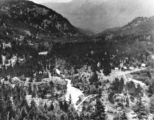
This photo [pg. 106] from the Skagit County Historical Society Series- "Last Frontier in the North Cascades" by Will D. Jenkins. Ruby Creek enters from the high Cascades at lower right in the photo.

SLATE CREEK MINING DISTRICT

      In the early 1890s, gold was discovered on Slate Creek and a second rush was underway. Eventually the Ruby Creek Mining District became the Slate Creek Mining District, with most mining activity moving eastward from Ruby's mouth to the new district. In his 1892 report on Skagit County Mines and Mining, Paul W. Law noted that according to the auditor's record, 740 claims had been located during 1890 and 1891 along the Ruby Creek drainage "and some of them have made a good many prospectors happy of the rich finds of 'nuggets they secured from their claims." Law mentioned that while most of the mining was done by "panning and rockers," several companies worked the ground using hydraulic systems, "as water is available on both sides of the creek from numerous of [sic] mountain streams dashing down into the main creeks." [94]

REFERENCES:
87. Thompson 1970, 90-91
      Rowley returned again in 1877, traveling with Otto Klement, Charles Von Presentin, John Duncan, and Frank Scott. This trip was more exploratory than Rowley's previous trips. The group left the banks of the Skagit, hiked over Cascade Pass, and down the Stehekin valley to Lake Chelan. An excursion on the Methow valley in search of rumored gold proved fruitless but the men returned to the lower Skagit River with new information about the unknown region.
88. Washington Standard, 24 October 1879. Hereinafter cited as WS.
89. WS, 19 December 1879.
90. Wuorinen 1975, 14.
91. Thompson 1970, 91-2.
92. Hodges, Lawrence K., editor. Mining in the Pacific Northwest. Seattle: Seattle Post-Intelligencer, 1897. Shorey Book Store Reproduction, Seattle, 1967: p. 56. Hereinafter cited at Hodges 1897. 93. Thompson 1970, 94.
94. Law, Paul W. Papers, Cascade Mining District Report, 1892, University of Washington Libraries, Manuscripts. Hereinafter cited as Law Papers.
95. Hodges 1897, 58.


RUBY CREEK JOINS THE SKAGIT
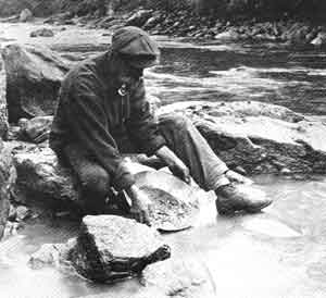
Again from the Skagit County Historical Society Series- "Last Frontier in the North Cascades" by Will D. Jenkins. PANNING GOLD [pg. 107] ...One of the few pictures ever taken of John McMillan, Ruby Creek pioneer packer and miner who came into the Upper Skagit from Ontario in 1883. McMillan had a homestead on Big Beaver Creek and for many years ran a roadhouse at the junction of the Ruby and Upper Skagit trails.
Both photos from the Thompson collection.

SETTLEMENT PATTERNS IN THE NORTH CASCADE UPPER SKAGIT


      There are several other early residents of the upper Skagit River whose homestead locations remain unknown. John Sutter is one of these. Sutter was a miner who first visited the area in 1872 with several other prospectors. Traveling by Indians canoes as far as present-day Newhalem, the party continued on by foot, crossing the river periodically and panning its banks for gold at each opportune moment. At the mouth of Ruby Creek the prospectors found gold, and, as the story goes, Sutter, while washing gravel found a large ruby stone in his pan. In recognition of his discovery Sutter named the creek Ruby. It is not known when he became a permanent resident or where he actually lived; the only historical reference to Sutter is found in USFS Ranger Tommy Thompson's diary of 1907, wherein he mentioned "Sutters Ranch on the Skagit. [67]
      Thompson also mentioned going up to Martin's ranch on the south side of the Skagit River in 1907. This ranch may have belonged to Jerome Martin who had a place in the vicinity of Marblemount for over thirty years. In 1905 Jerome Martin's land was valued at only $15, but the farm was not his principal livelihood. [68] Martin operated a pack train of horses, which carried supplies to miners in the Ruby Creek and Thunder Creek. [69]
      North along the Skagit River from Marblemount, five homesteads were located in Section 7 on the 1894 GLO map; situated alongside the river, an "unknown" homesite, "S.D. [?] Davis," "Emory," "J. Failana" (possibly Fatland but incorrectly recorded) and "M. Clard" were all recorded. [70] Continuing on into the next section to the north (Section 6), "John Buller" located a homestead on the West Side of the river, and William McAllister had a "clearing" directly across the river (T35N R11E, Section 6). This "clearing" was probably McAllister's homestead claim of 131 acres, which he purchased in 1896. [71] A 1903 Skagit County directory records McAllister's land valued at $85; it appears that by 1905-6, McAllister had left the area. [72] McAllister was also a miner who attempted to establish a livelihood for himself by prospecting along Thunder Creek. McAllister Creek, a drainage off Thunder Creek, is named after this early upper Skagit resident.

SETTLEMENT PATTERNS IN THE NORTH CASCADES


      The Skagit River is the largest watercourse in the North Cascades, an impressive channel through this mountainous country. In earlier days it flowed freely, quietly winding its way south from Canadian headwaters through densely forested lowlands until it reached Ruby Creek and changed to a southwesterly course. From there its waters were compressed and violently forced through narrow, rock-walled canyons and gorges. Farther downriver, near Newhalem, the channel widened and the raging waters flowed calmly again, unimpeded, to Puget Sound.
      This wild country is now submerged beneath the waters of Ross, Diablo, and Gorge Lakes. But even before the upper Skagit River's course was altered, and despite the nature of the surrounding landscape, people sought homesites along its banks. From the 1880s until the early years of the twentieth century, both miners and settlers claimed the loamy river bottomlands that offered both fertile, tillable soil, and access to the mountain interiors. The opportunity to supply travelers with goods sparked some settlement. Temporary or seasonal employment with government agencies offered Skagit River settlers the chance to supplement their simple existence. For some, the remote and rugged character of the region may itself have been a factor that encourages settlement. All of these incentives worked to bring homesteaders to Marblemount and the upper Skagit River; as many as ten of these early settlers eventually established permanent homesites within the boundaries of today's national park.
      Explorers and surveyors were the first whites to observe the lands drained by the upper Skagit River. No Euro-Americans inhabited the upper Skagit region until the 1880s, when prospectors began penetrating the mountains regularly in search of minerals. With miners came their outfitters - those who provided meals and lodging, transportation up and down the Skagit River, and backcountry guide and horsepacking services to and from the mining claims.
      Homesteaders in the true sense of the word also came into the area, arriving by canoe or following the rough trail built by the miners along the Skagit's north bank. They located their isolated homesteads on the best available land along the river. Few crossed the Skagit to settle because it meant abandoning an important link to civilization (the trail), as well as repeated and often dangerous river crossings for mail and supplies, and further seclusion from travelers and neighbors.

REFERENCES:
29. Neal, John B. "Pioneers still live who saw Birth of Marblemount." Bellingham Herald, 27 January 1957.
30. For additional information on the Davis family in this document see "Cooidors of settlement: Skagit River."
104. A long time resident of the area, Glee Davis had an extraordinary interest in keeping the story of Goodell's Landing alive for future generations. On his own initiative in the 1960s he contructed a scale model of the original trading post at the landing, complete with bunkbeds, stoves, and a counter as was found in the original building. It is a true piece of folk sculpture, in which Davis incorporated materials from a variety of former upper Skagit structures; the exterior logs are from his family's ranch at Cedar Bar, the roof shakes are from an old mining cabin on Thunder Creek (Middle Cabin perhaps), the interior floor from pieces of the Ruby Creek flume (of 1898), and the piece of rock near the model's kitchen door is a chip removed from the original rock still located on Dohne's former property. A small reconstructed tree stump included with the model was made of wood from the 1891 miner's bridge, the first horse bridge to span the Skagit River. Originally viewed at Davis' home in Sedro-Woolley, this unique and intriguing composite of the past can be seen today in Newhalem, Washington, at the National Park Service visitor's center. [Davis, Glee, "Text to Accompany Model of Goodell's Landing," n.d. Typescript.]
"The Land of Silent Shadows"
Written by Catherine Savage Pulsipher; originally typed & arranged by Mabel Boyd Royal-Steen; typed & transcribed by Larry Spurling; arranged & compiled the Stump Ranch, Dan Royal ©
LINK to Part I

Return to The Stump Ranch Family & Community History
© 2004, 2003, 2002 The Stump Ranch