Site founded September 1, 2000, passing 375,000 page views in April 2005
These home pages remain free of any charge. We need donations or subscriptions/gifts for students, military and family. Please pass on this website link to your family, relatives, friends and clients.

(Seattle & Northern 1890)

Skagit River Journal

of History & Folklore
Subscribers Edition Stories & Photos
The most in-depth, comprehensive site about the Skagit.

Covers from British Columbia to Puget sound. Counties covered: Skagit, Whatcom, Island, San Juan. An evolving history dedicated to the principle of committing random acts of historical kindness
Noel V. Bourasaw, editor (bullet) 810 Central Ave., Sedro-Woolley, Washington, 98284
Home of the Tarheel Stomp (bullet) Mortimer Cook slept here & named the town Bug

(Click to send email)

Former Mount Baker eruptions
in 1846 and 1792, and the
Mount Vernon logjams


When did Mt. Baker erupt? Moore sets Date in 1846
By Maurice Helland, undated Mount Vernon Herald, 1949
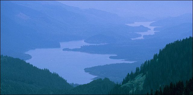
(Baker lake and river)
This marvelous photo by Phil Armitage is a view looking north from the Skagit river and the North Cascades that shows Baker Lake — which was formed when the dam on the Baker river was constructed, and the river beyond it. You can see Phil's beautiful photos of Mount Baker and many other mountains at this website. And this website has more photos and many facts about the mountain..

      Looking up at majestic Mount Baker, rearing its snowy crown above lesser peaks along the northern horizon, did you ever wonder how long the mountain has had its present familiar silhouette? When did the last eruption after the rugged outlines of north Puget Sounds great landmark?
      This was a question that intrigued Allen R. Moore, when, as a young surveyor on a vacation trip to the west, he first came to the Puget Sound country in 1909. Though he has proved to his own satisfaction that the latest eruption of the now quiet volcano occurred in, or very near, the year 1846, Mr. Moore has never found historical proof of this estimate.

Geology detective
      It is on scientific deduction that the Mount Vernon man, now retired but for a number of years a U.S. mineral surveyor, bases his opinion of the eruption date. In a way his quest for information on the mountain is a detective story, on a massive scale.
      His geological sleuthing dates back to that first trip to Washington 40 years ago, which started out as a game-hunting expedition but proved to be at least as much a hunt for facts about the mountain and for a new place to locate with his family.
      Trips in 1910 and 1911 added to his information on the mountain and to his liking for western Washington and particularly Mount Vernon, so in 1912, Mr. and Mrs. Moore and their seven children moved west from Missouri, where Mr. Moore had been a county surveyor. This community has been the family home ever since.

Follows clues, finds lava chunks
      After his first trip Mr. Moore wrote to his college geology professor, Dr. George D. Groff, [professor of Natural Sciences at Bucknell university], about his observations at Mount Baker and the geologist was immediately interested, since at that time no recent eruption in the United States had been heard of.
      The clues that Prof. Groff gave Mr. Moore provided a start for the life-long pursuit of information on the Mt. Baker eruption that still is a major interest for the Mount Vernon man, now nearly 83.
      Following the advice of the geologist, Moore noted the presence of magnetite and pumice stone, observed chunks of cracked lava rock that had apparently been blown miles into the air and deposited five miles or more from the edge of the cone, and checked on tree rings where lava flow or slides had wiped out earlier vegetation.
      Under the chunks of lava on Goat ridge they ranged from the size of pumpkins to barrels. Moore found evidence that the rock had been warm enough to search vegetation when it fell and that it had fallen with enough force to bruise solid rock and to splatter out like a tossed mud-pie.
      In numerous expeditions to the mountain the mount Vernon man found places, particularly in the vicinity of the Joe Morovits [or Morevits] ranch near Baker lake, of trees sliced off by slides and lava. He checked on the new growth which Morovits, an early settler, had seen grow up from small trees, and determined by counting tree rings that the eruption had occurred before 1848, probably a couple of years earlier.

Computes data
      Later, with his son Bill, Moore made tree-ring computations on trees which had been cut deeply by rocks loosened by the eruption and was able to determine quite conclusively that the year of the disaster was 1846. Moore's study of the mountain covered the entire area around the peak, but he found the most interesting evidence of the eruption in the Park, Swift and Rainbow creek areas. Climbing to the peak twice, he descended into the crater in 1918 and found evidence that the volcano was not extinct. He noted four hot air vents through the perpetual snow and ice and examined two of them closely. Mr. Moore even descended into one of the vents far enough to take up with his own hands pieces of warm sulphur which gave off an overpowering odor. Even years later, Mr. Moore recalls, it was possible to see evidence of Mt. Baker's smouldering activity from the Morovits ranch. Just at sunset, wisps of smoke could be seen emerging from the silhouetted cone of the peak. Years of correspondence with every agency and individual Mr. Moore could think of in an effort to find out historical facts about the eruption have yielded practically nothing, the Mount Vernon man says. Some years ago he appealed through the [Mount Vernon] Daily Herald for information and was told by Allen Wells of a history of British Columbia, probably long since out of print, which mentioned the fact that Hudson's Bay company employees had seen the [1846] eruption from the Fraser [river] valley.

Seeks history
      From this, Mr. Moore deduces the eruption took place in the summer, when the Hudson's Bay men would have been traveling. But efforts to locate the volume have been fruitless. Mr. Moore is still seeking information on the eruption and would welcome any clues from readers. Though failing eyesight makes it impossible for him to read, or even to see the unique collection of geological specimens and Indian relics which line the walls of his sudy, his interest in his life-long quest is undiminished.
      And if proof were needed that his knowledge of geology, surveying and astronomy is still as fresh as in his active years, Mr. Moore provided it when he served as a very successful witness in a claim-jumping case in Alaska last fall. Accompanied by his son, William C. Moore, the octogenarian geologist-surveyor made the long trip north in October, offered testimony to back up a survey he made years ago in the government service, and returned to his pleasant fir-shaded home in Mount Vernon.
      Ed. note: Allen R. Moore died in 1953, four years after this article was published. His son, William C. Moore died in 1988. We hope that another descendant of this family will write to us if they have any of Mr. Moore's records or can provide any follow-up to this story.


Background material re: Allen R. Moore's
observations of the 1846 eruption

Professor Fred G. Plummer's Paper on "Recent Volcanic Activity"
Read Before the Academy of Science.

Tacoma Ledger, Feb. 28, 1893

      The announcement that Mr. Plummer would read a paper on "Recent Volcanic Activity in Washington," drew to the Annie Wright seminary a full attendance of the Academy of Science last night. Some brief routine business was quickly transacted, including the appointment of a committee to arrange with the Alpine club to form the fifth department of the academy, and another committee to consuls with the Commercial club and chamber of commerce regarding an extra edition of the pamphlet containing Judge Wickersham's recent paper on "Mount Tacoma."
      Professor Fred G. Plummer's paper was listened to with close attention, it follows in full:

      During the preparation of this paper the writer has become convinced that he runs some risk of being call an alarmist, and indeed he must confess, after a careful study of the subject, there is cause for some apprehension. To say the very least, it will not be an over-exercise of caution for engineers and architects to give this subject more than a passing thought. What may occur in the future is entirely a matter of speculation-accurate prediction is impossible. But we may study the history of this locality and from it form our opinions as to what may possibly, if not probably, happen at any moment and without warning.
      The Puget Sound valley lies nearly north and south. The sun, moon and planets rise in the Cascades and set behind the Olympics. In this lowland nearly eighty miles in width are already many flourishing cities, surrounded by fertile lands, unlimited forests of timber, a wealth of minerals and with every facility for commerce. It is the very nearness of our mountain ranges- with their inexhaustible resources of coal and minerals and water power that will in time give us supremacy in the commerce of the world; but we will do well to remember that we are living in a part of the world just made, and that we view on every side the most recent of the volcanoes of this vast range — the American Andes.
      Bordering the Sound country there are at least twenty prominent peaks from which eruptions may take place, or which may be centers of earth tremors or shocks, and several of these have within recent years given ample proof of life. [Tables of mountains, eruptions and earthquakes are listed in the source] . . .
      The explorer, Fremont, says that on the 13th day of November, 1843, two of the great snow cones (Mounts Tacoma and St. Helens) were in action. "On the 23rd of November, St. Helens scattered its ashes like a light fall of snow over the Dalles of the Columbia fifty miles away," and it was still burning on February 16,1844, when another witness described it thus, "The mountain burned most magnificently. Dense masses of smoke rose up in immense columns and wreathed the whole crest of the peak in sombre and massive clouds, and in the evening its fires lit up the flaky mountain side with a flood of soft, yet brilliant radiance." . . .
      Father De Smet testifies that "in the year 1846 Mounts St, Helens and Baker became volcanoes, the latter immediately preceding the time of writing had undergone considerable changes on the side where the crater was formed," This corresponds in some degree to the story of John Hiaton, although the dates are not the same. It is also reported that Mount Tacoma showed signs of activity at this time.
      Settlers of Whatcom County have often seen Mount Baker in a state of eruption, giving out fire and smoke. One old resident says he has at night upon the water, several times seen the fires of Mount Baker, the smoke from which draws down the Skagit valley. Parties who reached the summit in the year 1866, report that the chasms on the northwest side are of frightful depth. The top of the mountain is of solid ice and snow, The crater lies to the southward and far below the summit. From the top smoke was plainly seen coming from the crater and a sulphurous smell was plainly perceptible.
      In January 1853, persons living down Sound could distinctly see a long. black streak on the southwest slope of Mount Baker which was variously estimated at from 1,000 to 2,000 feet in width. It was several months before this mass of lava (as it undoubtedly was) had cooled so as to receive the falling snow. Persons who reached the summit in 1881, report that just south of the peak is an enormous chasm bearing nearly east and west and at least 1,000 feet below the summit. At the bottom of this chasm is the crater, and it was from its western mouth this river of lava flowed..


Skagit River Journal editor's
research re: 1792 eruption of Mount Baker

By Noel V. Bourasaw
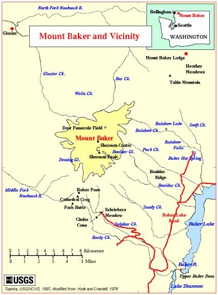
(Close-up Mount Baker map)
This USGS map is modified from: Hyde and Crandell, 1978, USGS Professional Paper 1022-C and shows a close-up of Mount Baker and its environs, including the Nooksack, Skagit and Baker rivers. The Baker river at the lower right was heavily impacted by the 1792 eruption of Mount Baker.

      A few years before I found the story about Mr. Moore in the files of the Territorial Daughters of Washington, at the LaConner Historical Museum, I became curious about a possible earlier major eruption of Mount Baker. The question occurred to me in the mid-1990s when I read the memoirs of Otto Klement, which Ethel Van Fleet Harris collected. Klement arrived at the Skagit river valley in 1873 and explored the river and the North Cascades in depth over the next decade. In a 1935 letter to Mrs. Harris, he wrote:
      At this point [just south of future Mount Vernon] the river came to a sudden end, at least so it would have appeared to a person not familiar with the situation. A jam of driftwood here spanned the river for a distance of a mile and a half up stream. This jam had existed so long that it had become water-logged and had sunken to varying depths. Its surface was in an advanced state of decay, and overspread by a heavy coat of river marl and supported a forest growth scarcely distinguishable from that prevailing on the river's banks. this forest rose and fell with the rise and fall of the river. In times of flood, owing to the settling and shifting of the mass in the upper regions of the jam, a weird note of groaning was produced, not unlike that of a monster in pain, while sharp reports of breaking timber could be heard for miles around.
I became curious about his observation about Klement's observation that the trees growing from the logjam so far down the river were similar in size to the trees growing on the banks. As a child growing up near the river, I often saw small jams of trees lodged against bridge pilings after a flood but I had never seen a tree growing out of such a pile or jam. I began wondering what could have delivered such a mass of earth and driftwood that an island could be created in the river and then support a new mini-forest. So I went back and read the passage from the 1906 book, Illustrated History of Skagit and Snohomish Counties:
      The great jam consisted of two divisions, the lower beginning at the old Kimble homestead below Mount Vernon and extending up the river to a point about opposite the present Kimble residence, a distance of perhaps half a mile. The upper part of the jam was considerably larger, beginning about half a mile above the upper end of the lower jam and extending over a mile. The lower one was believed to be at least a century old and was probably much older, while the upper one was to all appearance of comparatively recent formation. It was increasing in size very rapidly. Dennis Storrs, to whom we are indebted for much valuable information respecting this matter, states that within three years after his arrival, a quarter of a mile of debris had accumulated at its upper end. [Storrs settled in 1875 on a homestead that stretched from the district called Harmony up to what later West Mount Vernon.]
      Beneath and between the tangled mass of debris the river was obliged to force its passage and in places beneath the lower jam there were twenty-four feet of water at the lowest stage. The material of the jam was mainly green timber, but in many places sediment had accumulated to such an extent as to permit the growth upon it of a perfect jungle of brush and even of large trees. . . . [Eldridge Morse's Snohomish City newspaper, The Northern Star, Dec. 16, 1876] notes the fact that the men had at that time been working nearly a year, had reduced the portage distance one and one half miles. The paper describes the magnitude of the task by stating that the men were compelled to cut through from five to eight tiers of logs, which generally ranged from three to eight feet in diameter, representing a total cutting out of a space thirty feet deep. . . . Sometimes trees four feet in diameter were snapped off like so many pipe stems. . . .
      The peripatetic Star man has preserved an interesting picture of the appearance of the work in progress at that time upon the Skagit jam. [In 1878] he found two flourishing logging camps . . . [where] the correspondent noticed one tree without crook or knot from which were cut four twenty-four foot cuts, scaling upwards of six thousand feet of clear lumber each.

      If such a log were at least 96 feet long, I wondered, how long would it have taken to grow? I consulted with several old-time loggers and learned that the log was most likely Douglas fir, since there was neither a crook nor knot, and that it would grow at an average of a foot or slightly more per year. That is when my mind started buzzing. Could a catastrophic flood or event on the river have washed down an extreme number and mass of logs sometime in the century before, which could have caused the massive blockage of the horseshoe bend near Mount Vernon, and deposited enough soil and nutrients that a large number of trees could grow from it? I recalled that sometime during my research, I had read that either the crew of Captain Vancouver or a Spanish explorer had observed an eruption of Mount Baker in the 1790s. Could such an eruption and resulting pyroclastic flow have uprooted masses of trees and pushed them violently south, down the Baker river and then into the Skagit river?
      I looked everywhere but could not find the original reference. Over the next few years, I searched every text I could find in various libraries, but to no avail. I hit the same wall that Mr. Moore did above. Then I happened to find a most interesting website [see: http://volcano.und.edu/vwdocs/frequent_questions/grp7/north_america/question1348.html ] where a reader submitted a similar question and was answered by a noted volcanologist authority.

      Mount Baker has erupted at least 10 times since 1792. Since that time there have also been 8 unconfirmed eruptions. The last confirmed eruption began September 7, 1880 and lasted about two and a half months. There may have been an eruption in 1884 but it has not been confirmed. Sherman Crater was the vent for all of these eruptions. — Steve Mattox, University of North Dakota
— Sources of Information: Tom Simkin and Lee Siebert., 1994, Volcanoes of the World, Geoscience Press, Tucson, Arizona, 349 p

That is what either researchers or argonauts call a Eureka! moment. Excited at having my amateurish theory partially confirmed, I then sought out Mr. Mattox, but again to no avail. But I was ultimately successful in finding James Luhr, who also studies volcanoes and was associated with Simkin and Siebert through the Smithsonian Institute. And he finally led me to Mr. Siebert, who replied to my inquiry:
      Your inquiry was of interest to me as a former Whatcom County resident who has spent a fair bit of time in the Skagit River drainage of the North Cascades. In fact, my wife and I just took advantage of a Christmas trip back home to check out the eagles on the Skagit. I'm not aware of any web sites with more detailed information about the 1792 eruption of Baker, but our source was the book by Stephen Harris titled Fire Mountains of the West, which was published by Mountain Press in 1988 (and has had subsequent editions). Harris stated that the log (published in an anonymous narrative in 1802) of a Spanish expedition reconnoitering Bellingham Bay in June 1792 noted that the crews of the vessels Sutil and Mexicana recognized in "the ominous rumbling and flashes of fire to the east that continued day and night signs of a volcanic eruption." This may be one of the contemporary accounts you have already seen, and detailed descriptions of the 1792 eruption are not likely to exist. Your account of the rooted trees on a log jam is of interest in this context. The USGS has ongoing studies of lahar (mudflow) deposits from Mount Baker. Although many relatively small deposits of the past few centuries have been found, I'm not sure that 1792 deposits have specifically been identified. As noted in the USGS report, the last major eruption of Baker was about 6600 years ago.
      We owe many thanks to the late Mr. Moore, Mr. Siebert and all the people mentioned above for helping answer a question that arose from our own ignorance. As happens many times in our research, we have to learn a little bit — just enough to be dangerous, about many things in order to satisfy our curiosity and inform our readers. I hope that someone who knows more than I do about the subject will add more knowledge about the 1792 event and the formation and growth of the logjams.

More sources:

Story posted on April 23, 2005
Did you enjoy this story? Please consider subscribing to the optional Subscribers Edition. That is how we fund this grand project.
Please report any broken links or files that do not open and we will send you the correct link. Thank you.

You can read about our prime sponsors:
Read the history websites of our sponsors and supporters, who help fund research of local history:
Heirloom Gardens Natural Foods at 805B Metcalf street, the original home of Oliver Hammer.
Oliver Hammer Clothes Shop at 817 Metcalf street in downtown Sedro-Woolley, 82 years.
Bus Jungquist Furniture at 829 Metcalf street in downtown Sedro-Woolley, 36 years.
Schooner Tavern/Cocktails at 621 Metcalf street in downtown Sedro-Woolley, across from Hammer Square.


Peace and quiet at the Alpine RV Park, just north of Marblemount on Hwy 20
Park your RV or pitch a tent by the Skagit river, just a short driver from Winthrop or Sedro-Woolley.


Would you like to buy a country church, pews, belfry, bell, pastor's quarters and all? Email us for details.
Looking for something special on our site? Enter name, town or subject, then press "Find"
Search this site powered by FreeFind
Did you find what you were looking for? If not, please email us and tell us what you seek and we will put it on our list to research. The more details, the better.
Please sign our guestbook so our readers will know where you found out about us, or share something you know about the Skagit River or your memories or those of your family. Share your reactions or suggestions or comment on our Journal. Thank you for taking time out of your busy day to visit our site.
Sign Our Guestbook Get your own FREE Guestbook from htmlGEAR
View Our Guestbook
Remember, we welcome correction and criticism. Please click on the email slot at the right to report any problems with these pages or to suggest ideas for future stories. This is a completely free site. We fund it by providing an online magazine for paid subscribers. If you are not already a subscriber and you would like to help support our considerable research costs, you can subscribe for just $20.00 per year. As a paid subscriber, you will receive eight yearly issues plus many rare treats between times, including scans of photos and documents that illustrate local history, before they are shared with anyone else. You can go here for Subscription details and you can read the preview edition to see examples of our in-depth research. You may also order gift subscriptions for friends, family or clients who are interested in local history or students or military people who are away from home. Or you can email us for more details. Do you have scanned photos to share? Or you can mail us copies. See addresses to right.
Email us at: journal@stumpranchonline.com
(Click to send email)
Mail copies/documents to street address: Skagit River Journal, 810 Central Ave., Sedro-Woolley, WA, 98284.